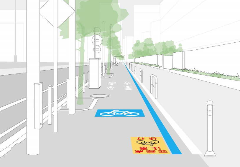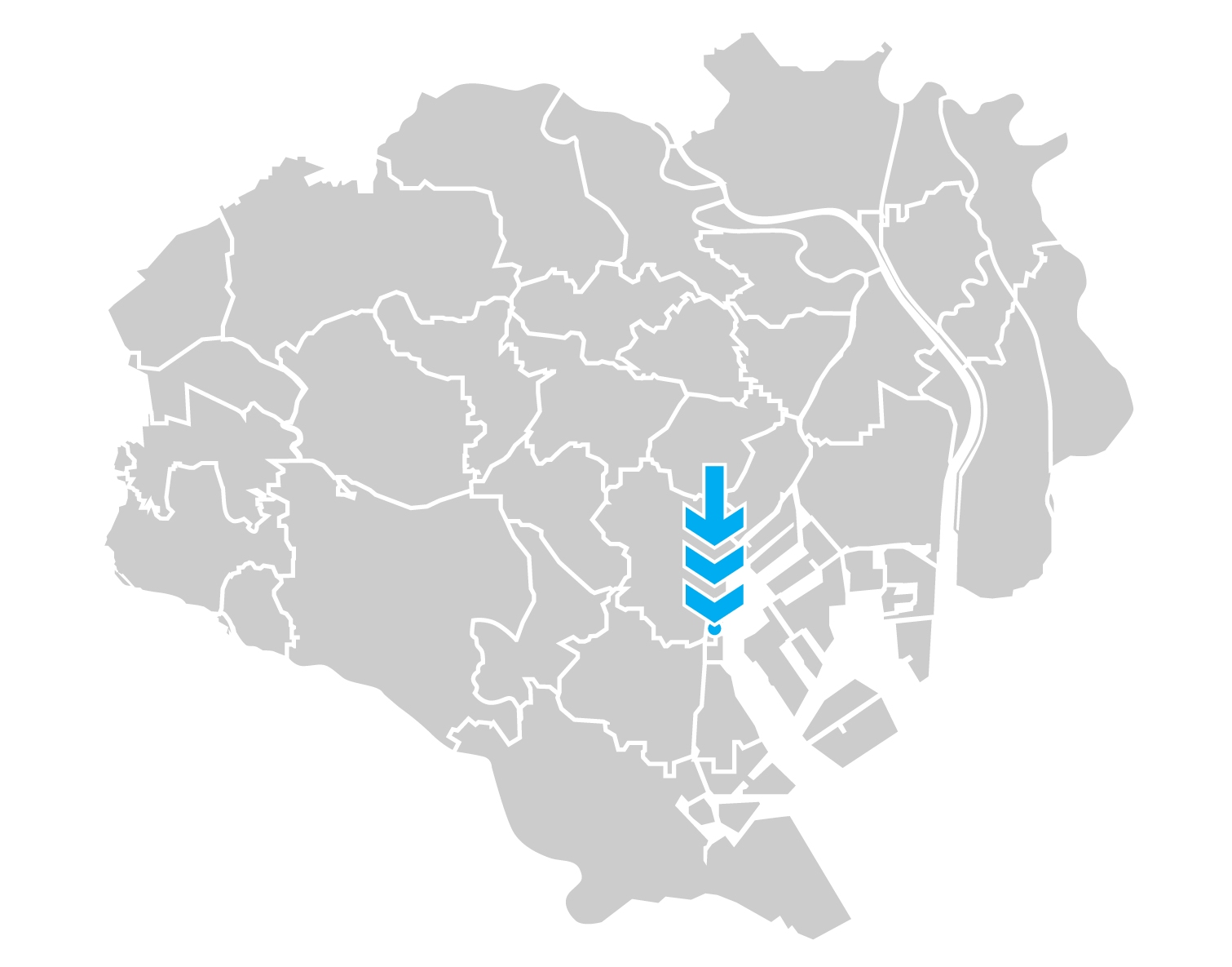
The Konan sidewalk lanes are located approximately 600 meters east of Shinagawa Station and run on both sides of the road for about 180 meters between the Tokyo University School of Marine Science and Konan Elementary School.
These lanes are nicely set off from the pedestrian sidewalk to the left with blue and white lines and paving blocks of a lighter color, and take advantage of the very wide sidewalk space with large painted graphics on the lanes and on overhead signs.
The street is connected with another parallel street one block north that actually has parking protected bike lanes (which didn’t make it into the top 5 due to the lane being in the door zone), by two other local streets with bike lanes and sharrows respectively, both of which are often blocked by parked cars.
Konan deserves credit for being willing to experiment with the ample space available in the area. Now they need to commit to a plan and put it all together into better bike lanes and a cohesive network.
品川駅から東に600mほどの地点から始まるこの自転車通行空間は、東京海洋大学前から港南小学校前までの約180mに亘って道路両側の広大な歩道上に整備されている。
青と白の2本の区分線で歩行者空間から区別されているのが特徴的だ。路面のピクトグラムも青背景で強調されておりよく目立つ。
1ブロック北には都道480号のparking-protected bike laneが並行している(駐車車両のドアゾーンと重なっているためトップ5には食い込めなかった)他、都道480号との間を結ぶ2本の区道にもそれぞれ自転車ナビライン、自転車専用レーンが整備されている(いずれも路上駐車で塞がりがち)。
港南地区は豊富な空間資源を活かして自転車通行空間のネットワークを形成しようという意欲が見られる点が評価できる。今後はそれぞれの通行空間の質を上げ、より広域のネットワークを構築する計画に取り組む必要がある。
SAFETY / 安全性 ( 7.6 )
Transition Points – Only attempt to prevent pedestrian collisions is a warning sign on the ground (these fade or get damaged over time).
終端部の処理——歩道に切り替わる地点での歩行者との衝突防止策は注意を呼びかける路面表示のみ(経年劣化で読めなくなりがち)。
Cohesion – Near its end on the east runs Kaigan Dori, a north-south artery with only a wide sidewalk on each side (the roadway is for motorized vehicles only), but near the other end on the west is another, narrower north-south street to <480> with on-street bike lanes, and between these is a bidirectional one-laner with blue chevrons (share-the-road arrows).
ネットワーク品質——自転車通行空間の東端の港南小学校前交差点で接続する南北方向の幹線道路、海岸通りは車道通行が禁止されており、幅の広い歩道があるだけだが、西端の少し先にある東京海洋大学前交差点から都道480号線へは車道に自転車専用レーンの施工された南北の区道があり、これらの間には車道に自転車ナビライン(青い矢羽根)の施工された細い区道がある。
Obstacles – The path disappears at bus stops. Sign posts, utility poles and tree bases are at-grade and encroach on useable bike path space.
障害物の有無——自転車通行空間がバス停の手前で途切れている。標識・照明の支柱や植栽桝が同一平面上にあり、通行空間に食い込んでいる。
Traffic Separation – There are U-shaped bollards interspersed between the pedestrian and bicycle areas. This only partially prevents pedestrians from using the bicycle side of the path.
交通モードの分離——歩行者空間と自転車空間の境目にはU型ボラードが数メートルおきに並んでいるが、歩行者が自転車空間に入り込んでしまうのを防ぐ効果は限定的だ。
Lighting – Illumination is provided by both street lamps on the path side and additional lamp posts in-between. So good job on the lighting at least.
照明――車道と自転車通行空間を別々に照らすメインの街灯に加えて補助的な街灯も設置されている。少なくとも照明は良好といえる。
DESIGN / デザイン ( 7.5 )
Communication – The path is clearly marked with both ground markings and overhead signs. This still doesn’t seem to help keep the pedestrians off the marked area.
通行方法の伝達——自転車通行空間は路面表示と頭上の看板で明確に示されているが、それでも歩行者が入ってきてしまうのを防ぐには不十分なようだ。
Understandable – The signs use mainly standard pictograms (pogostick and riderless bicycle) but ground warning signs at the exit alert of pedestrian collisions using both pictograms and Kanji text, making it hard to understand the message from the pictograms alone.
言語依存性——路面表示と看板には都内でよく用いられているピクトグラム(自転車ナビマークと自転車単体のマーク)が使われているが、歩行者との衝突防止が目的と思われる終端部の路面表示は漢字とピクトグラムの併用で、ピクトグラムだけ見ても意味が理解できない。
Promotes Safety – The design does not completely separate the pedestrian zone and it looks like absolutely no thought was put into intersections and bus stops.
事故防止——この通行空間設計は自転車と歩行者の空間を完全には分離していない。特に交差点やバス停の周辺では交錯を防止するための思考が完全に放棄されているように見える。
Transition Instructions – There are indications where the lane starts and it is clear when it ends but no other information about where a cyclist should go (on the street, remain on the sidewalk, other).
終端部の案内表示——自転車通行空間の終端部は明確に示されているが、その先で自転車利用者がどこを通行すれば良いのか(車道に出るのか、引き続き歩道を通行するのか)の案内が全くない。
USEAGE / 利用状況 ( 7.5 )
Popularity – There are many large residential buildings in this area, a daycare, and office space, which would indicate a high usage. However, at a cursory glance there appeared to only be a marginal amount of cyclists in proportion to the number of residents in the area.
通行台数——この地域には高層マンションや託児施設、事務所などが多数立地しており、自転車交通量もそれなりに期待できるはずだが、少しの間見ていた限りでは、地区人口に対してごく僅かな割合の人しか自転車に乗っていないようだった。
Broad Spectrum – Users were older and some mothers with electric assist bicycles used the path.
利用者の多様性——自転車通行空間の利用者の年齢層は高めで、電動アシスト自転車に乗った母親の姿も散見された。
Scalable – It seems the lanes are serving cyclists pretty well, but for them to be a safe and comfortable space for a larger number of people on various kinds of bikes, they would have to be expanded from their current width, preferably taking away vehicular space although it’s often politically challenging.
拡張性——今のところ自転車通行空間の幅は十分なようだが、自転車交通量が増えた場合や、リヤカー付き自転車、カーゴバイクなどの大型自転車の通行も考慮するなら、今より幅員を広げなければ安全性と快適性が維持できないだろう。政治的に困難な課題となることが多いものの、拡幅の際には車道を削って空間を確保するのが望ましい。
Majority Preference – Seniors and parents tended to use the bike path but delivery and recreational bicyclists used the road.
通行空間の選好——高齢者と子供の保護者はこの自転車通行空間を選ぶ傾向が見られたが、配達やサイクリング目的の人々は車道を通行していた。
Total 22.6 / 合計 22.6点
IMPROVEMENTS / 改善案
CURRENT / 現状

We understand budget limitations and this is probably the best that could be built within the budget. However, it may be better to make a proper investment when it comes to making a city look good, feel safe, and work well for all users.
予算に限りがあることは分かるし、恐らくこれがその予算内で行える精一杯の整備なのだろう。けれども、街をあらゆる利用者にとって見た目にも魅力的で、安全で、機能的に優れたものにするためには、相応の投資をすべきなのではないだろうか。
TIPS / 改善案のポイント

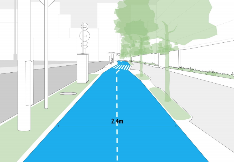
A minimum of 2.4m wide bi-directional path takes some space away from the vehicle area and pedestrian area. The lane will connect so there is no need for the abrupt warning signs.
A utility island protects from the street traffic and bus stop island provides a safe place for bus passengers to wait for the bus.
The trees are moved to a center location to provide shade for the road users who need to be cooled and have some sun protection (people in cars are already out of the sun). Trees should also not block the road signs (safety). The tree barrier is permeable allowing for cyclists from businesses and schools to enter and exit the bike lane freely. Road drainage and sidewalk / bike lane drainage are separated.
車道と歩行者空間を少し削り、最低2.4m幅の双方向通行の自転車道を実現。途切れていた部分を連続させ、唐突な注意喚起表示を不要に。
緩衝帯/施設帯は車道の交通の流れから自転車利用者を保護し、島式バス停はバス利用者に安全な待機スペースを提供。
街路樹を歩行者空間との境界部に移動し、歩行者と自転車の空間両方に涼しい木陰ができるようにしている(自動車に乗っている人は既に日差しから遮られている)。街路樹が標識を隠してしまうことも防げる(安全面の考慮)。自転車利用者が自由に店舗や学校などと通行空間との間を行き来できるよう、分離構造物として機能する街路樹は間隔を空けて配置。車道の排水と歩道・自転車道の排水は別系統に。
Illustration purposes only. Feasibility studies would need to be conducted for viability for cost, local ordinances, and other unknown specification.
イメージは一例。費用、法令との整合性、その他さまざまな制約を考慮した上での実現可能性は別途調査が必要と思われる。


